|
|
Duzer, Chet Van. “The Mythic Geography of the Northern Polar Regions: Inventio fortunata and Buddhist Cosmology”. Culturas Populares. Revista Electrónica 2 (mayo-agosto 2006). http://www.culturaspopulares.org/textos2/articulos/duzer.htm ISSN: 1886-5623 |

The
Mythic Geography of the Northern Polar Regions:
Inventio
fortunata and Buddhist Cosmology
Chet Van Duzer
University
of California, Berkeley
Abstract
This article compares the
mythical geography of the northern polar regions in two very distinct
traditions: a western European tradition based on a lost 14th
century book titled Inventio fortunata, and the traditional Brahmanic Hindu and
Buddhist conception of the earth. Both of these traditions involve a high
mountain at the top of the world and water flowing in or out from this mountain
in four streams that flow as if to the four cardinal points. Both traditions
were represented cartographically. It is extremely unlikely that one of these
traditions influenced the other; rather, it is an interesting case of strong
similarities between two completely distinct conceptions of sacred centers.
Key Words
Mythical Geography. Northern
Polar Regions. Inventio fortunata. Brahmanic Tradition. Hindu Tradition. Buddhist
Tradition.
Resumen
Este artículo compara la
geografía mítica de las regiones polares septentrionales en dos tradiciones muy
distintas: la europea occidental que se basó en un libro perdido del siglo XIV
titulado Inventio
fortunata, y la concepción tradicional budista y brahamánica hindú de la
tierra. Ambas tradiciones involucran una gran montaña en la cima del mundo y
agua que fluye hacia adentro o hacia afuera de ella en cuatro corrientes hacia
los cuatro puntos cardinales. Ambas tradiciones se representaron
cartográficamente. Es muy improbable que una de estas tradiciones haya influido
a la otra; más bien es un caso interesante de fuertes similitudes entre dos
concepciones completamente diferentes de centros sagrados.
Palabras clave
Geografía mítica. Regiones
del Polo Norte. Inventio fortunata. Tradición brahamánica. Tradición hindú. Tradición
budista.
Where is the center of
the world? Is it the omphalos in the adytum of Apollo’s temple at Delphi? The “Navel of
the World” pillar in the catholicon of the Church of the Holy Sepulcher in Jerusalem?[1]
The temple of Madhyameshrava, “The Lord of the Center,” in the holy city of
Benares, India? Easter Island in the South Pacific, whose ancient name, “To Pito
o Te Henua,” means “The Navel of the World”? The stone marking Kilomètre Zéro
on the Ile de la Cité, Paris, just in front of Notre Dame? The Kanro-dai pillar
at the Tenrikyo Main Sanctuary in Tenri, Japan? The monument at El Mitad del
Mundo, 22 km north of Quito, Ecuador? Lake Poso in the center of the island of
Sulawesi, Indonesia, the pivot of the earth and heavens, and the spot where a
rope once joined the two?
Sacred
centers are usually located near the people in whose mythology they play a
part,[2]
but there are distant spots on the earth that many different peoples recognize
have a special central status: the North and South Poles. These spots are
pierced by the axis of the heavens; they are the crowns of the world, about
which all the stars dance, the points to which all compasses direct their
needles. The recognition of the centrality of the earth’s poles is reflected in
one of the names of sacred centers, axis mundi, as well as in various attempts to connect
sacred centers with the Poles. The city of Beijing is known as the “Pivot of
the Four Quarters,” and the sacred center of the city, the Forbidden City, is
more precisely known as the “Purple Forbidden City” (Zi Jin Cheng), purple
being the symbolic color of the North Star, and the designation “Purple
Forbidden City” thus signifying that the emperor’s residence is the center of
the world.[3]
There was also a ninth-century Islamic tradition, argued by al-Kisa’i of Kufa,
that the Kaaba in Mecca (for which “the center of the earth” is a common
epithet among Muslims) is located directly beneath the North Star.[4]
Thus
symbolism of or connection with the Pole (in this paper I will be dealing
almost exclusively with the North Pole) is often ascribed to local sacred
centers, while the Pole itself, until this century both in belief and in fact
unattainable, has received little mythological attention as a center. I will
examine two systems of mythology relating to the northern polar regions,
systems which, though from very different cultures, turn out to be remarkably
similar.
Gerardus
Mercator (1512-94) is perhaps the only figure in the history of cartography
whose name has become a household word, and his system of map projection,
called the Mercator projection, is still widely used today, albeit usually in
slightly modified forms. Mercator was famous for his meticulous research and
accuracy, and thus it is quite a surprise to see for the first time Mercator’s
map of the northern polar
regions, Septentrionalium terrarum descriptio (1595)[5]:
the map shows a North Pole that is very unfamiliar to modern eyes (see figure
1). At the center of the map, and right at the Pole, stands a huge black
mountain; this mountain was made of lodestone, and was the source of the
earth’s magnetic field.[6]
The central mountain is surrounded by open water, and then further out by four
large islands that form a ring around the Pole. The largest of these islands
perhaps 700 by 1100 miles, and they all have high mountains along their
southern rims. These islands are separated by four large inward-flowing rivers,
which are aligned as if to the four points of the compass– though of
course there is no north, east, or west at the North Pole: every direction from
this center is south. Mercator’s notes inform us that the waters of the oceans
are carried northward to the Pole through these rivers with great force, such
that no wind could make a ship sail against the current. The waters then
disappear into an enormous whirlpool beneath the mountain at the Pole, and are
absorbed into the bowels of the earth. Mercator also tells us that four-foot
tall Pygmies inhabit the island closest to Europe.
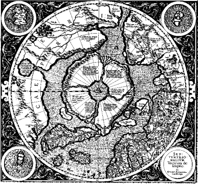
Fig. 1. Septentrionalium
terrarum descriptio by Gerardus Mercator (1595). Mercator and other cartographers are quite
clear that the rivers flow inward towards the pole, though the deltas at the
southern ends of the rivers seem to suggest that the rivers are flowing
outward. Courtesy of the Association of Canadian Map Libraries and Archives.
More
remarkable than this map itself is the fact that many other contemporary maps,
maps by the most respected cartographers of the time, show a very similar
configuration around the North Pole. Martin Behaim, who died before Mercator
was born, made a famous globe in 1492 (this is in fact the oldest surviving
terrestrial globe) that shows land surrounding the North Pole. There are two
large islands right near the Pole in the western hemisphere, while extensions
of Europe and Asia reach northwards so as to form, together with the two
islands just mentioned, a broken circle of land around the Pole. A world map by
Johannes Ruysch, the Universalior cogniti orbis tabula, published in an edition of Ptolemy’s Geographia
in Rome in 1508, shows four
islands around the North Pole; two (the one north of Greenland and its opposite
across the Pole) are labeled “Insula Deserta”; the one north of Europe is that
of the Hyperboreans; and the one north of America is labeled “Aronphei.” He
labels the waters within the four islands as the “Mare Sugenum,” and speaks of
a violent whirlpool that sucks the incoming waters down into the earth; in
addition, his map shows a ring of small, very mountainous islands around the
four islands, which numerous islands Ruysch says are uninhabited.
Other
maps that show these northern islands include:[7]
Orontius Finaeus’ Nova et Integra Universi Orbis Descriptio, published in 1534-6, but designed about 1519
for Francis I; Abraham Ortelius’ famous Typus Orbis Terrarum (1570) and also his Septentronalium regionum
descriptio (1570), which
latter follows Mercator particularly closely; the anonymous world map in George
Best’s True Discourse
(London, 1578); Cornelius Judaeis’ Speculum orbis terrae of 1593, as well as his maps of Quiviriae
regnum and Americae pars
borealis (also 1593; see
figure 2); and Petrus Plancius’ Orbis terrarum typus de integro multis in
locis emendatus (1594),
published in Jan Huygen van Linschoten’s Itinerario (1596), as well as his influential Nova et
exacta terrarum orbis tabula geographica ac hydrographica (Amsterdam and/or Antwerp, 1592). There are
many, many other contemporary maps –literally scores, including examples
from as late as the 1700s[8]–
that show the same configuration of islands around the Pole.
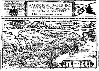
Fig. 2. Americae pars borealis by Cornelius Judaeis (1593).
Parts of two of the four northern islands, labeled “[TERRA] INCOGNITA,” stretch
across the top of the map. Courtesy of the Association of Canadian Map
Libraries and Archives.
The
suggestion that there must be a large mountain of lodestone at the North Pole
to account for the earth’s magnetism goes back to at least the 13th century,
not long after the invention of the compass,[9]
but what was the source of the four islands and the inward-flowing rivers, of
the mountains and the Pygmies? Mercator cites his authority for his delineation
of the northern regions: the Itinerarium of a Flemish traveler named Jacobus Cnoyen (now lost); Cnoyen gave as
his sources the Res gestae Arturi britanni (now lost), and a book written by an English Minorite, a mathematician
from Oxford, who had traveled in the far north in 1360 and recorded what he
saw; this work was called the Inventio fortunata, which also, (ironically, in light of its
title) is lost.[10] Ruysch cites the same sources, and Fridtjof
Nansen argues convincingly that Behaim was working from the Inventio
fortunata also.[11]
Mercator and his contemporaries believed the author of the Inventio
fortunata, the English
Minorite, to be Nicholas de Linna (Nicholas of King’s Lynn); others have argued
against this identification.[12]
Thus
the source of this mythical polar geography is a lost work by an unknown author
of the 14th century. Nonetheless, it is possible to speculate about where the
author of the Inventio fortunata may have derived this geography. Fridtjof Nansen has found mentions of
a great northern whirlpool in Norse legends of the world’s well, “Hvergelmer,”
which causes the tides by pushing and pulling water through its subterranean
channels, Isidore of Seville (c. 560-636), the Gesta hammaburgensis
ecclesiae pontificum of Adam
Bremensis (11th century), the Topographia hibernica of Giraldus Cambrensis (1146-1220; his
description of the northern whirlpool is cited by Mercator), the Historia
norvegiae (c.1180), the Speculum
regale (c. 1250) of Einer
Gunnarson, and a particularly interesting quote from the Langobard author
Paulus Warnefridi (c. 720-790), also called Diaconus:[13]
And not
far from the shore which we before spoke of, on the west, where the ocean
extends without bounds, is that very deep abyss of waters which we commonly
call the ocean’s navel. It is said twice a day to suck the waves into itself,
and to spew them out again; as is proved to happen along all these coasts,
where the waves rush in and go back again with fearful rapidity.... By the
whirlpool of which we have spoken it is asserted that ships are often drawn in
with such rapidity that they seem to resemble the flight of arrows through the
air; and sometimes they are lost in the gulf with a very frightful destruction.
Often just as they are about to go under, they are brought back again by a
sudden shock of the waves, and they are sent out again thence with the same
rapidity with which they were drawn in.
Delno West has argued
that for the author of the Inventio fortunata, the whirlpool at the North Pole represented
an entrance to Hell, which was believed to be in the center of the earth, and
also that the four inward-flowing rivers and whirlpool are the counterpart to
the fountain in the Garden of Eden, whence the four great rivers branch out to
water the world (see Genesis 2:10-14)
if the rivers flow out, they must flow back in somewhere and be recycled.[14]
West’s
argument that the author of the Inventio fortunata saw the whirlpool as an entrance to Hell seems
far-fetched, as neither the map makers nor any of the author’s likely textual
sources for the whirlpool mention that it was an entrance to Hell. West’s
suggestion of a connection between the northern whirlpool and the fountain in
the Garden of Eden is very intriguing, but it must be noted that there is no
evidence that Behaim, Ruysch, Mercator, and the other cartographers who
followed the geography of the Inventio fortunata believed that the northern whirlpool was the
counterpart to the fountain in Eden. The Garden of Eden may have been a fixture
on medieval mappae mundi
(i.e. world maps more or less contemporary with the Inventio fortunata; see for instance the Hereford Mappa Mundi of
c. 1280), but it appears on none of the maps under consideration here. Indeed
the Jesuit polymath Athanasius Kircher (1602-80), who published the earliest
chart of the global ocean circulation in his Mundus subterraneus (1665), and who follows the geography of the Inventio
fortunata in asserting that
there is a whirlpool at the North Pole sucking in the waters of all the oceans,
also asserts that the waters emerge again, not in Eden, but at the South Pole.[15]
Nonetheless, I believe that the analogy between the polar geography of the Inventio
fortunata and the Garden of
Eden is important.
The
persistence of the Inventio fortunata geography on maps for, say, 150 years is to some extent a testament to
the esteem in which Mercator and Ortelius were held by other cartographers; it
is also, I think, a testament to the great psychological and mythical power of
the concept of the center. It was well-known that the North Pole was the true
center of the earth, and the author of the Inventio fortunata gave an account of the geography that was so
mythologically satisfying, that it continued to be believed or at least
repeated well past the time when scholars and explorers knew that the account
was false. Many sacred centers are aligned to the four cardinal directions: the
Purple Forbidden City has four gates opening out to the four cardinal
directions; the Throne Room of the Royal Palace of King Mindon, a perfect
square oriented to the cardinal directions, was in the middle of Mandalay,
which is thought to be the center of Burma, and hence of creation; above the
throne room rose a gold-plated, seven-story, 256 ft tower or pyathat, which was thought to funnel the wisdom of the
universe to the king in its center.[16]
The Great Temple of Tenochtitlan (now Mexico City) was at the center of the
island, the first spot colonized, and the spot where the eagle eating the
serpent on the cactus was seen, and the sacred precinct had gates in the four
directions. And many other examples of sacred centers oriented to the cardinal
directions come to mind– not least the Garden of Eden with its four streams.
The Inventio
fortunata places a mountain at
the Pole, and of course many sacred centers are mountains; a passage into the
depths of the earth is another common feature of sacred centers. Moreover, the
powerful flow of water from the four corners of the earth in through the rivers
to the Pole, and there down a whirlpool, is the strongest possible confirmation
and emphasis of the Pole’s centrality, as strong almost as the thought of
millions of Muslims facing Mecca from all corners of the earth five times a day
in prayer. This role the North Pole plays in the circulation of the earth’s
waters gives the spot the global importance we expect of a sacred center. Also
a number of sacred centers seem to be connected with primal waters: the Garden
of Eden again; the Rock of the Temple of Jerusalem, which closes “the mouth of
the tehom,” or the watery
chaos beneath the earth that was involved in Noah’s flood; Uisneach Hill in
Ireland, seat of the Stone of Divisions, and the center of Ireland according to
the division of the country made by the god Fitnan, son of Ocean, was also the
source of the waters of the Deluge; and the mountain Haraiti or Alburz, to the
east of Iran, which is the “navel of waters,” as the fountain of all waters
springs there. And a text by Mich-Tzu dating from the era of Liu-ch’ao
(420-588) places the Chinese Isles of the Immortals at the point where all the
waters of the earth and the rivers of the Milky Way flow together.[17]
Thus
the surprisingly long survival of the Inventio fortunata geography reflects the mythological power of
that geography: it asserted a polar configuration consistent with people’s
expectations for one of two spots on the planet pierced by the celestial axis.
The
other example of northern polar mythology I would like to examine is the
Brahmanic Hindu and Buddhist conception of the earth.[18]
Brahmanic Hindu and Buddhist mythology is very complex, partly because of the
creativity of Indian mythographers, which results in many different versions of
each myth, and partly because Indian mythographers rarely abandoned old ideas
or theories, but continued to present them alongside new ideas, even when the
new and the old were inconsistent; the complexity may increase even further,
when one cosmological scheme, for instance, is presented not merely alongside
another, but is encapsulated within another.[19]
I will look at an early and relatively simple Hindu/ Buddhist conception of the
earth, which may be found as part of many later and more complicated schemes:
the catur-dvipa vasumati, or
“four continent earth” model.
In
Bhramanic Hindu and Buddhist belief, the earth’s sacred center is (quite
unusually) not near at hand, but far off to the north, on a separate,
unattainable continent:[20]
the center is Mt. Meru or Sumeru or Sineru, and it is the axis mundi, the fixed point about which the heavens
revolve; its summit is the dwelling-place of the Trayastrimsa gods, the highest
of the six Buddhist worlds of gods. According to the “four continent earth”
model, the earth’s continents are arranged in the form of a lotus flower.[21]
Mt. Meru stands at the center of the world, the pericarp or seed-vessel of the
flower, as it were, surrounded by circular ranges of mountains. Around Mt.
Meru, like the petals of the lotus, are arranged four island-continents (dvipas), aligned to the four points of the compass:
Uttarakuru to the north, Ketumala or Aparagoyana to the west, Bhadrasva or
Pubbavideha to the east, and Bharata or Jambudipa to the south; Jampudipa is
the part of the world inhabited by humans.
The
dimensions of all these elements are fantastic. Mt. Meru is 84,000 yojanas (420,000 miles) high,[22]
and the island-continent of Jambudipa, which includes India, is 10,000 yojanas (50,000 miles) in extent, with the area
occupied by the Himalayan Range and human habitations being 3,000 yojanas (15,000 miles) in extent. The level of detail
in the descriptions of all these mythical regions is astonishing: there are
named mountain ranges, rivers, and races of semi-divine beings everywhere, and
we learn the height of each of the races, how long they live, and the shape of
their faces. In addition, it was held that on or near Mt. Meru was Lake
Anotatta (or Anawdat), which was the source of the world’s rivers. The lake is
surrounded by a mountainous rim, and through rocky openings in this rim shaped
like the heads of an ox, horse, lion, and elephant, four rivers flow to the
south, east, north, and west, respectively. These rivers flow three times
around Anotatta in spirals, and then continue in their original directions towards
the four cardinal points. The river flowing to the south (from the ox’s head)
is the proto-Ganges; after dashing against a mountain, spurting high (60 yojanas/ 300 miles) in the air, falling back to earth,
and following an underground course, it emerges to form five rivers whose names
can be traced to rivers in northern India, namely the Ganges and its
tributaries.[23]
Mt.
Meru is the point about which the heavens revolve, the axis mundi, and thus something very similar to the North
Pole of the Buddhist/ Hindu universe. Indeed, the North Star was held to stand
directly above Mt. Meru, linked by ropes of wind to all the heavenly bodies.[24]
The spot beneath the North Star should, according to our conceptions, be the
North Pole; but the cosmographical texts in this tradition hold that the earth
is a flat disc or shallow bowl, and thus the concept of a North Pole is absent.
The continent Uttarakuru was held to be north of Mt. Meru, and indeed the
particle “uttara” means “north.”
However,
there is a very long tradition of Indian cosmological globes: such globes (or bhugolas) were known to the Indian astronomer Aryabhata
(b. 476), and are frequently described in medieval Indian texts.[25]
Transferring the terrestrial features of Hindu cosmography from a flat disc to
a sphere required a number of changes, the most important of which was that Mt.
Meru was moved to the North Pole. The pericarp of the lotus now being at the
North Pole, the petals of the lotus, the four continents, stretch southward
from Mt. Meru towards the equator, and the continent Uttarakuru, whose name
implied that it was north of Mt. Meru, has its name changed to Kuruvarsa. One
such globe, probably made in Orissa in the early to mid-nineteenth century, but
depicting cosmological traditions that are centuries older, is illustrated in
figure 3.[26]
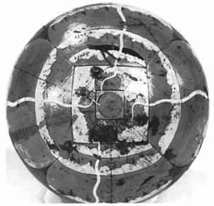
Fig. 3. Wooden cosmological
globe made in Orissa, India, 19th century. The view is straight down on Mt.
Meru at the North Pole, which is circled by mountain ranges (three ranges on
two of the continents, one on the other two continents); four rivers flow from
Mt. Meru as if to the four points of the compass down the middle of the four
faint island-continents, which stretch southward to the equator. Courtesy of
the Board of Trustees of the Victoria and Albert Museum, London (I.M.
499-1924).
The
similarities between the Inventio fortunata and the Brahmanic Hindu and Buddhist
conceptions of the northern polar regions of the earth should by now be
obvious. Both place a large mountain at the Pole surrounded by four islands
aligned as if to the four points of the compass. From the one mountain radiates
the earth’s magnetic field; the other is the pivot of the universe, and the
home of the divine. And while the while the Inventio fortunata has the waters of the world’s oceans flowing
in towards the Pole from the four quarters and then down into the earth, the
Buddhist conception has a large lake with four huge rivers flowing out to the
four corners of the earth. Of course there are many differences between the two
conceptions: the one is a secular or geographical mythology, the other divine,
and there are differences of scale, differences in degree of elaboration, the
difference between water flowing in and water flowing out, and others. But the
similarities are impressive.[27]
To
attempt to argue that the Inventio fortunata was by some circuitous means derived from
Buddhist conceptions of the northern polar regions would be at best a highly
precarious undertaking. Quite aside from the inherent improbability of such an
influence, when the work itself is lost and its author uncertain, no such
argument can have a foot to stand on. I am inclined rather to see the fact that
two so similar mythographies of the northern polar regions should arise and
persist in two so different cultures as a testament to both the creativity of
these two cultures, and to the degree to which these mythographies match our
innate transcultural conception of what a sacred center should be.